
What AI says about GreenValley International LiPowerline
GreenValley International LiPowerline is a LiDAR point cloud processing software for power-line inspection developed by GreenValley International.
AI calls itspecialized,automates asset extraction,precise,dedicated,utility-focused,automated AI classification
Since Jul 5Updated Nov 8, 2026Based on 5,656 AI answers Reviewed by Dimitry Apollonsky


Products
- GreenValley International LiPowerlineThis page2%
- LiDAR3601%
2%
of AI answers about GreenValley International LiPowerline and its rivals · since Jul 5
Based on 5,656 AI answers
- ChatGPT1%
- Google AI Mode2%
How often AI mentions GreenValley International LiPowerline
of AI answers about GreenValley International LiPowerline and its rivals
Markets where AI mentions GreenValley International LiPowerline
- Drone Mapping & Surveying SoftwareChatGPTGoogle AI Mode
- Utility GIS and Vegetation Management SoftwareGoogle AI Mode
- Commercial Drone Inspection & Mapping SolutionsOutside both engines’ top 25
- Satellite Risk Intelligence PlatformsOutside both engines’ top 25
- Forestry Management Software PlatformsOutside both engines’ top 25


Topics where AI mentions GreenValley International LiPowerline
- AI picks mostMentioned in
- We need to inspect our transmission towers and lines. What is the best drone inspection service or platform for utility assets?on this questionAI picks Skydio most19%
- We need to manage our vegetation management program near power lines. What's the best vegetation management software that uses satellite or LiDAR data?on this questionAI picks LiveEO and 9 more about as often25%
- We need a solution to prioritize our transmission line clearing based on encroachment risks identified through remote sensing. Which software platforms offer advanced risk modeling for utility vegetation?on this questionAI picks AiDash and 1 more about as often15%
Excerpts where GreenValley International LiPowerline appeared in the AI's answer
Google AI ModeOct 29, 2026, Google AI Mode GreenValley International LiPowerline : A dedicated LiDAR processing and analysis tool
- We need drone inspection for pipelines, power lines, or solar farms. What platforms are best?on this questionAI picks DroneDeploy and 2 more about as often7%



GreenValley International LiPowerline in AI answers
We need a solution to prioritize our transmission line clearing based on encroachment risks identified through remote sensing. Which software platforms offer advanced risk modeling for utility vegetation?
Sites AI cites
- Your site30%
- LiPowerline LiDAR point cloud processing power line inspection software - GreenValley International (opens in a new tab) · 22%Leaves GreenValley International LiPowerline out
- Introduction · LiPowerline User Guide (opens in a new tab) · 4%Leaves GreenValley International LiPowerline out
- GreenValley International LiPowerline (opens in a new tab) · 2%
- Exercise 2: Vegetation encroachment detection · GVI Tutorials (opens in a new tab) · 2%
- Leaves GreenValley International LiPowerline out28%
- LiPowerline: The leading software for ultra-efficient power line inspection with drones (opens in a new tab) · 11%Leaves GreenValley International LiPowerline out
- Transforming Powerline Inspections with Drones (opens in a new tab) · 4%
- LiPowerline: The leading software for ultra-efficient power line inspection with drones (opens in a new tab) · 4%
- LiPowerline V9 - AI-Powered LiDAR and Photogrammetry Processing Software (opens in a new tab) · 2%Leaves GreenValley International LiPowerline out
- LiPowerline V9 - AI-Powered LiDAR and Photogrammetry Processing Software (opens in a new tab) · 2%
- Using Drones for High Voltage Transmission Line Inspection (opens in a new tab) · 2%
- How to Use LP360 Drone for Power Line Encroachment - YouTube (opens in a new tab) · 2%
- Leaves GreenValley International LiPowerline out11%
- LiPowerline | LiDAR Power Analysis Software | Mirai Aerospace (opens in a new tab) · 9%Leaves GreenValley International LiPowerline out
- LiPowerline | Powerline LiDAR Analysis Software – Mirai Aerospace (opens in a new tab) · 2%
- Leaves GreenValley International LiPowerline out9%
- Buy GreenValley LiPowerline Software | Dronefly – DroneFly (opens in a new tab) · 7%
- GreenValley LiDAR Point Cloud Processing Software | Dronefly – DroneFly (opens in a new tab) · 2%Leaves GreenValley International LiPowerline out
- Leaves GreenValley International LiPowerline out2%
- Power Line Vegetation Encroachment Report : r/UAVmapping (opens in a new tab) · 2%Leaves GreenValley International LiPowerline out



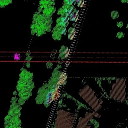


The page AI cites most for GreenValley International LiPowerline
Brands AI mentions
Mentioned in
- ArcGIS19%
- Esri18%
- Optelos2%
- LP3602%
- Lidarvisor1%